
Tuesday, October 26, 2010
La Niña Strengthens
Fire-Breathing Storm Systems

Monday, October 18, 2010
The Greenhouse Effect
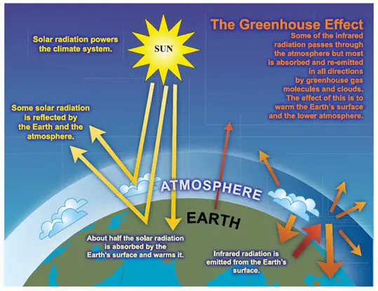 The greenhouse effect is the rise in temperature that the Earth experiences because certain gases in the atmosphere (water vapor, carbon dioxide, nitrous oxide, and methane, for example) trap energy from the sun. Without these gases, heat would escape back into space and Earth’s average temperature would be about 60ºF colder. Because of how they warm our world, these gases are referred to as greenhouse gases. The Earth’s atmosphere is all around us. It is the air that we breathe. Greenhouse gases in the atmosphere behave much like the glass panes in a greenhouse. Sunlight enters the Earth's atmosphere, passing through the blanket of greenhouse gases. As it reaches the Earth's surface, land, water, and biosphere absorb the sunlight’s energy. Once absorbed, this energy is sent back into the atmosphere. Some of the energy passes back into space, but much of it remains trapped in the atmosphere by the greenhouse gases, causing our world to heat up. The greenhouse effect is important. Without the greenhouse effect, the Earth would not be warm enough for humans to live. But if the greenhouse effect becomes stronger, it could make the Earth warmer than usual. Even a little extra warming may cause problems for humans, plants, and animals. (EPA)
New Species Found

Wednesday, October 13, 2010
Land 'Evapotranspiration' Taking Unexpected Turn
 Most climate models have suggested that evapotranspiration, which is the movement of water from the land to the atmosphere, would increase with global warming. The new research, published online this week in the journal Nature, found that's exactly what was happening from 1982 to the late 1990s. But in 1998, this significant increase in evapotranspiration, which had been seven millimeters per year, slowed dramatically or stopped. In large portions of the world, soils are now becoming drier than they used to be, releasing less water and off-setting some moisture increases elsewhere. Due to the limited number of decades for which data are available, scientists say they can't be sure whether this is a natural variability or part of a longer lasting global change. But one possibility is that on a global level, a limit to the acceleration of the hydrological cycle on land has already been reached. If that's the case, the consequences could be serious. They could include reduced terrestrial vegetation growth, less carbon absorption, a loss of the natural cooling mechanism provided by evapotranspiration, more heating of the land surface, more intense heat waves and a "feedback loop" that could intensify global warming.
Underwater Robot

Saturday, October 9, 2010
Facts on the Amazon Rainforest


Eiffel Tower

Sunday, October 3, 2010


Thursday, September 23, 2010


California
California is 155,959 square miles. In 2005, there were approximately 36,132,147 people living in California. There are 18 national forests and there are 278 state parks and beaches which cover about 1.5 million acres of land. California became a U.S. state in 1847 when Mexico surrendered it to John C. Fremont. James W. Marshall discovered gold on January 24, 1848 which then started the California Gold Rush and also brought a tons a settlers to the state. Some of the major industries are agriculture, manufacturing, transportation equipment, machinery, electronic equipment, biotechnology, aerospace-defense, and tourism. The main natural resources are timber, petroleum, cement, and natural gas. Death Valley, located in the southeast and is 282 feet below sea level, is the lowest point in the nation. There are a couple main attractions in California which are Yosemite National Park, Disneyland, Hollywood, the Golden Gate Bridge, Sequoia National Park, San Simeon State Park, and Point Reyes National Seashore. (Infoplease)
Wednesday, September 22, 2010


Friday, September 10, 2010
Niagara Falls
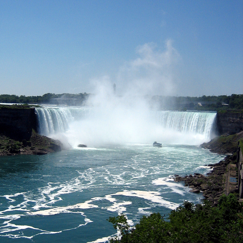
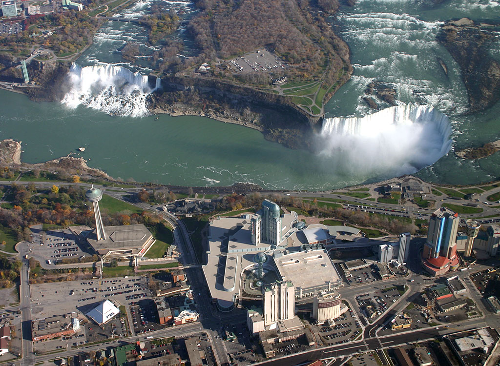 Niagara Falls is the most powerful waterfall in North America. The Falls are located between Buffalo, New York and Toronto, Ontario. The latitude and longitude coordinates are 43.080 degrees north 79.071 degrees west. Niagara Falls is separated, by Goat Island, into three different falls. The two falls that are on the left side of the island are the American Falls and the Bridal Veil Falls. The bigger one of the three, which is on the right side of the island, is called Canadian/Horseshoe Falls. The average height for the falls is about 170 feet. The Niagara Falls were created from the last ice age which was called, Wisconsin Glaciation. The last ice age also created the North American Great Lakes and the Niagara River. (FANF)
The Grand Canyon
The Grand Canyon, located in the northwest corner of Arizona, is one of the most spectacular examples of erosion in the world. The canyon is 277 miles long and a mile deep and it's separated into the south rim village and the north rim village. The climate and vegetation between the north and south are different due to the differences in elevation. The North Rim is the coldest and the wettest. It gets up to 26 inches of precipitation a year. The South Rim only gets around 16 inches of precipitation a year. The Inner Canyon is the closest to a desert as the lower you get, the hotter and drier it becomes. The bottom of the canyon is about 35°F hotter than the temperatures above. A neat and interesting fact about the Grand Canyon is that the colors of the rock change with the changing of the sunlight. (NPS)
Thursday, September 2, 2010
What is a hurricane?

 A hurricane is a powerful, swirling storm that begins near the equator and works its way towards the poles. The winds of a hurricane swirl around a calm central zone called the eye surrounded by a band dark clouds called the eyewall. The eye is usually 10 to 40 miles in diameter and is free of rain and clouds. In the eyewall, large changes in pressure create the hurricane's strongest winds. These winds can reach up to 200 miles per hour. Damaging winds may extend 250 miles from the eye. Hurricanes are referred to by different labels, depending on where they occur. They are called hurricanes when they happen over the North Atlantic Ocean, the Caribbean Sea, the Gulf of Mexico, or the Northeast Pacific Ocean. Such storms are known as typhoons if they occur in the Northwest Pacific Ocean, west of the International Date Line. Storms that are near Australia and in the Indian Ocean are called tropical cyclones. (NASA)
Hurricane Earl

Subscribe to:
Posts (Atom)