Thursday, September 23, 2010

Michigan

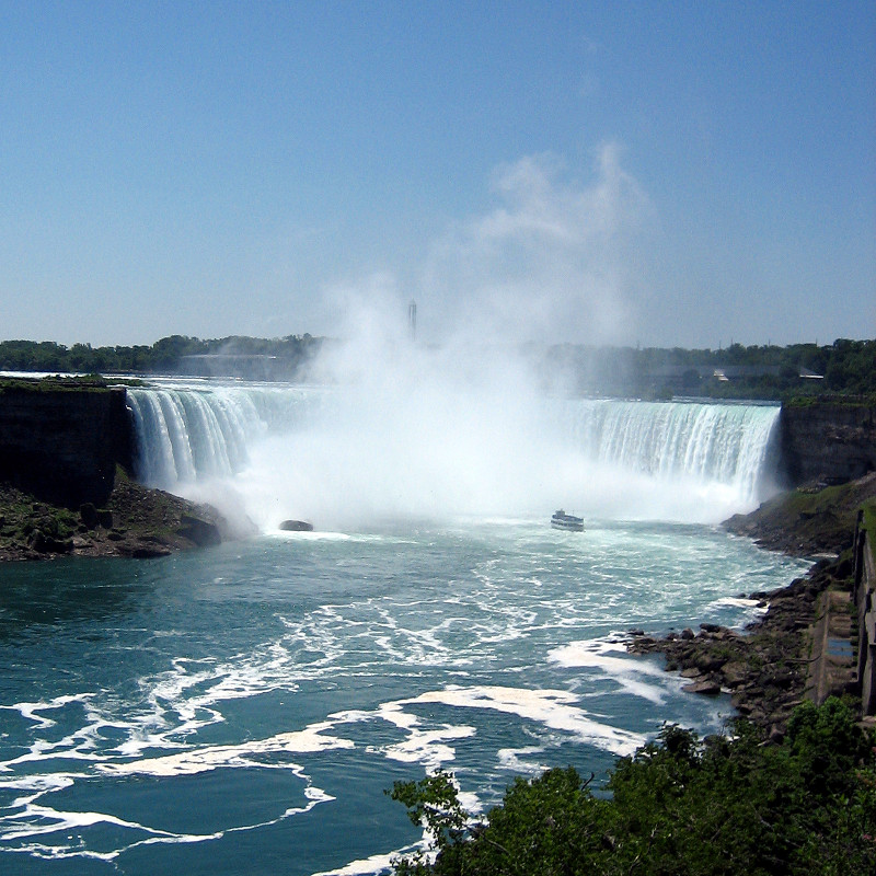
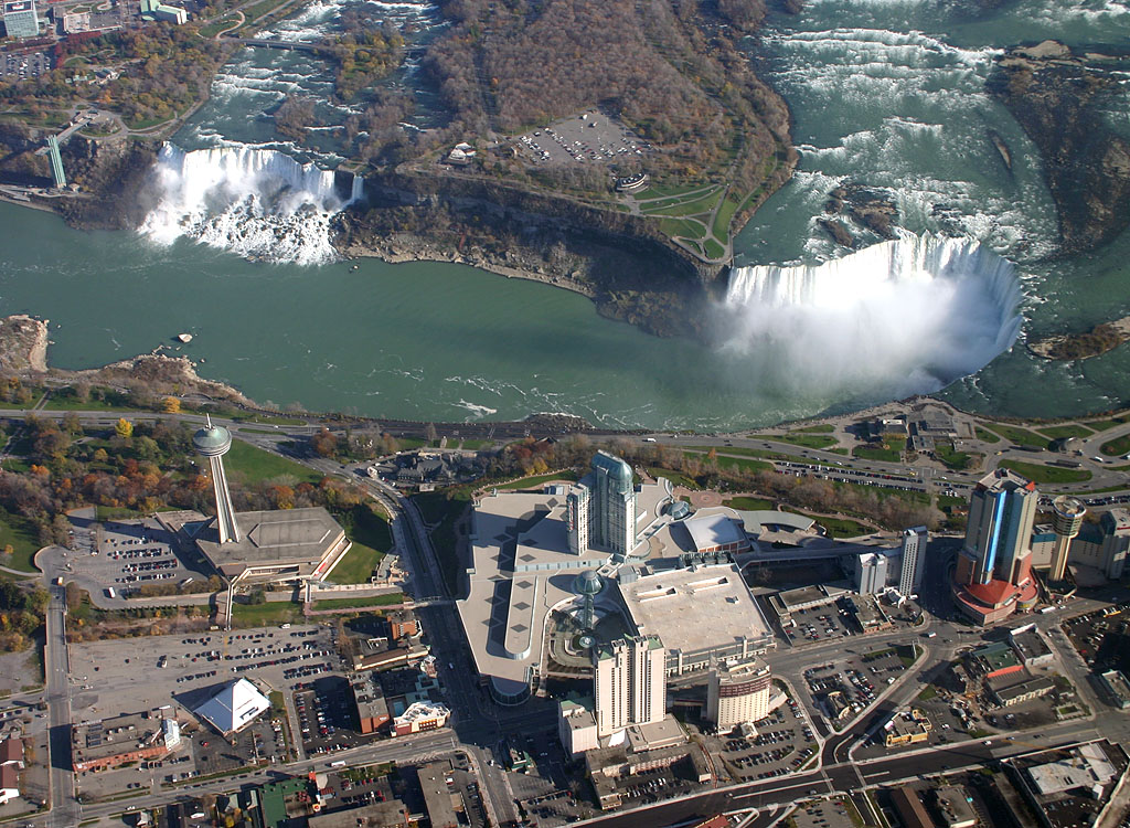
    Michigan ranks first among the states in production of motor vehicles and parts, it is also a leader in many other manufacturing and processing lines, including prepared cereals, machine tools, airplane parts, refrigerators, hardware, and furniture. The state produces important amounts of iron, copper, iodine, gypsum, bromine, salt, lime, gravel, and cement. Michigan's farms grow apples, cherries, beans, pears, grapes, potatoes, and sugar beets. Michigan's forests contribute significantly to the state's economy, supporting thousands of jobs in the wood-product, tourism, and recreation industries. With 10,083 inland lakes and 3,288 miles of Great Lakes shoreline, Michigan is a main area for both commercial and sport fishing. Some main attractions are the automobile plants in Dearborn, Detroit, Flint, Lansing, and Pontiac; Mackinac Island; Pictured Rocks and Sleeping Bear Dunes National Lakeshores; Greenfield Village in Dearborn; and the many summer resorts along both the inland lakes and Great Lakes.  Michigan covers 56,804 miles and has a population, in 2005, of about 10,120,860. (Infoplease)


Louisiana

    Louisiana is a leader in natural gas, salt, petroleum, and sulfur production. Much of the oil and sulfur comes from offshore deposits. The state also produces large crops of sweet potatoes, rice, sugar cane, pecans, soybeans, corn, and cotton.  Some of the leading manufactured items are chemicals, processed food, petroleum and coal products, paper, lumber and wood products, transportation equipment, and apparel.  The state, over time, has become a popular tourist destination for their picturesque French Quarter and the annual Mardi Gras celebration, which was held since 1838.  Some major attractions in Louisiana are the Superdome in New Orleans, historic plantation homes near Natchitoches and New Iberia, Cajun country in the Mississippi Delta Region, Chalmette National Historic Park, and the state capital at Baton Rouge.  On Aug. 29, 2005, Louisiana was hit by Hurricane Katrina, devastating New Orleans, and killing hundreds in the state.  Federal and local officials were criticized for their slow response to the initial disaster and recovery programs. (Infoplease)


California

    California is 155,959 square miles.  In 2005, there were approximately 36,132,147 people living in California.  There are 18 national forests and there are 278 state parks and beaches which cover about 1.5 million acres of land.  California became a U.S. state in 1847 when Mexico surrendered it to John C. Fremont.  James W. Marshall discovered gold on January 24, 1848 which then started the California Gold Rush and also brought a tons a settlers to the state.  Some of the major industries are agriculture, manufacturing, transportation equipment, machinery, electronic equipment, biotechnology, aerospace-defense, and tourism.  The main natural resources are timber, petroleum, cement, and natural gas.  Death Valley, located in the southeast and is 282 feet below sea level, is the lowest point in the nation.  There are a couple main attractions in California which are Yosemite National Park, Disneyland, Hollywood, the Golden Gate Bridge, Sequoia National Park, San Simeon State Park, and Point Reyes National Seashore. (Infoplease)


Wednesday, September 22, 2010

Colorado

    Colorado has the highest elevation of any state, with more than 1,000 Rocky Mountain peaks over 10,000 ft high. Pikes Peak, the most famous of these mountains, was discovered by U.S. Army lieutenant Zebulon M. Pike in 1806.  Colorado has a strong manufacturing base.  The main manufactures are food products, printing and publishing, machinery, and electrical instruments.  Another important element of the state's economy is farm industry which is most focused on more towards livestock.  The primary crops in Colorado are corn, hay, and wheat.  The main tourist attractions in the state include Rocky Mountain National Park, Curecanti National Recreation Area, Mesa Verde National Park, the Great Sand Dunes and Dinosaur National Monuments, Colorado National Monument, and the Black Canyon of the Gunnison National Monument.  In 2005, the total population was 4,665,117.  Colorado has 64 counties.  It also has 1 state forest which covers 71,000 acres and 44 state parks which covers 160,000 acres. (Infoplease)

Friday, September 10, 2010

Niagara Falls


Niagara Falls is the most powerful waterfall in North America.  The Falls are located between Buffalo, New York and Toronto, Ontario.  The latitude and longitude coordinates are 43.080 degrees north 79.071 degrees west.  Niagara Falls is separated, by Goat Island, into three different falls.  The two falls that are on the left side of the island are the American Falls and the Bridal Veil Falls.  The bigger one of the three, which is on the right side of the island, is called Canadian/Horseshoe Falls.  The average height for the falls is about 170 feet.  The Niagara Falls were created from the last ice age which was called, Wisconsin Glaciation.  The last ice age also created the North American Great Lakes and the Niagara River. (FANF)

The Grand Canyon

    The Grand Canyon, located in the northwest corner of Arizona, is one of the most spectacular examples of erosion in the world. The canyon is 277 miles long and a mile deep and it's separated into the south rim village and the north rim village. The climate and vegetation between the north and south are different due to the differences in elevation. The North Rim is the coldest and the wettest. It gets up to 26 inches of precipitation a year. The South Rim only gets around 16 inches of precipitation a year. The Inner Canyon is the closest to a desert as the lower you get, the hotter and drier it becomes. The bottom of the canyon is about 35°F hotter than the temperatures above. A neat and interesting fact about the Grand Canyon is that the colors of the rock change with the changing of the sunlight. (NPS)

Thursday, September 2, 2010

What is a hurricane?

    A hurricane is a powerful, swirling storm that begins near the equator and works its way towards the poles.  The winds of a hurricane swirl around a calm central zone called the eye surrounded by a band dark clouds called the eyewall. The eye is usually 10 to 40 miles in diameter and is free of rain and clouds. In the eyewall, large changes in pressure create the hurricane's strongest winds. These winds can reach up to 200 miles per hour. Damaging winds may extend 250 miles from the eye. Hurricanes are referred to by different labels, depending on where they occur. They are called hurricanes when they happen over the North Atlantic Ocean, the Caribbean Sea, the Gulf of Mexico, or the Northeast Pacific Ocean. Such storms are known as typhoons if they occur in the Northwest Pacific Ocean, west of the International Date Line. Storms that are near Australia and in the Indian Ocean are called tropical cyclones. (NASA)

Hurricane Earl

    According to CNN, Hurricane Earl has downsized to a category two hurricane.  Hurricane warnings and watches are all along the east coast.  Earl has had sustainable winds of 110 mph.  It is a very large storm measuring to about 166,000 square miles.  President Obama signed a disaster declaration for North Carolina on Wednesday evening. The action authorizes the Department of Homeland Security and the Federal Emergency Management Agency to coordinate relief efforts and makes federal funds available.  Maryland has also issued an emergency declaration.  Besides Hurricane Earl, there are two more tropical storms forming in the Atlantic, Fiona and Gaston, that will be closely watched.